Come to British Columbia

bcferry The motto for British Columbia is “splendour sine occasu” which means splendour without diminishment, and it is a splendid province. It is a land of towering snow-capped mountains, rushing, foaming rivers and trees so tall you can barely see the tops. It is also home to the only real desert in Canada, huge cattle ranches, and a warm sheltered spot where fruit trees grow. Because of this large variety in climate and landscape, British Columbia has the greatest variety of animal and plant life in Canada.

On the far western side of Canada, where the waters of the Pacific Ocean roll in and out every day, there are about 6500 islands and islets scattered down the coastline. These are the tops of mountains sticking out of the sea. They are mostly rocky wilderness and because the ocean keeps the temperatures fairly mild and wet, some of the tallest trees grow here in what is called the Coast Rainforest. One tree – a Sitka Spruce – in the Carmanah Valley on Vancouver Island is 95 metres tall!

Vancouver Island is the biggest of these islands and on its southern tip is the city of Victoria which is the capital of British Columbia. The mild weather here caused by the ocean means that quite often there are flowers blooming in the middle of winter. Spring usually begins much earlier here than in other places in the province.

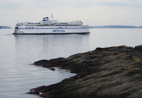
To get to the mainland, one would have to take a ferry ride or an airplane. The ferries that travel between Vancouver Island and the mainland are quite large. Some of them are the world’s largest double-end ferries. They are 167 metres long and can carry 1650 passengers and 470 vehicles each. The ferry trip would end up on the mainland near the large city of Vancouver – home to half of the population of B.C.

This is where the Fraser River empties into the ocean and the land is flat and rich and contains almost half of B.C.’s farms. It is nestled between the ocean and the Coast Mountains. Since it is up against the mountains, the clouds coming off the ocean must rise to get over them, and as the moist air rises, it cools and the water condenses and falls as rain or snow. Therefore Vancouver gets a lot of precipitation and over the mountains on the other side lies the interior plateau which gets very little.

The interior plateau is a high piece of rugged, rolling hills, sandwiched between the Coastal Mountains and the mountains further inland. The southern part of this interior plateau is the Okanagan Valley. Its soil is rich and its climate is sunny, warm and dry. Seven lakes spill down it’s centre, the biggest being Okanagan Lake, flowing into the Columbia River. Since it is does not get a lot of rain, people have had to figure out ways to get water to their fruit trees, vineyards and vegetables. At the southern tip of this valley, on the eastern shore of Osoyoos Lake is a little “pocket” desert where prickly pear cactus and sagebrush grow. It is called a pocket desert because it is surrounded by land that is not desert. It is home to many birds of prey including the endangered burrowing owl and other species of animals that are found virtually nowhere else in Canada.

To the north of the interior plateau is good grassland which provides the substance of many cattle ranches. The northeast of the province is The Peace River Valley. It is one of B.C.’s major agricultural areas centred on grain farming. North of this is mainly mountainous wilderness.

PROJECT: Find the following places on a map: Gulf Islands, Vancouver Island, Victoria, Queen Charlotte Islands, Vancouver, Okanagan Valley, Peace River Valley

The Beothuk

Beothuk camp

The Beothuk were the people originally inhabiting Newfoundland when Europeans first arrived. They were tall and strong, with dark eyes and black hair worn long in braids and decorated with feathers. They covered their bodies, clothes and weapons with red ochre mixed with oil. This protected their skin during the winter and against insects in the summer and they also believed it protected them from harmful spirits. Every spring they would gather by a lake or river for an ochering ceremony. During this ceremony they would apply a fresh coat of ochre to their skin and children born during the previous year would receive their first coating.

Each man had only one wife. The man looked after trapping, hunting and fighting. The woman cared for the children, looked after the fire, prepared food and made clothing. Elderly people were respected and stayed with the family.

The Beothuk tribe was broken down into bands of about 60-80 people. Each band had a chief who was respected by the people as a good hunter and leader. Decisions were made in a council.

Their clothing during cold weather was caribou hide, with the fur side against the body. The skins were scraped clean and then rubbed with animal brain. The hides were covered with red ochre to make them waterproof. They wore leggings, arm coverings, mocassins and mittens all made from caribou hide. A robe made of two skins sewn together crossed over the chest and was belted at the waist. It was trimmed with beaver or otter fur, with fringes decorated with shells, beads, animal teeth, claws and feathers tied on.

The men were excellent archers. They carved their harpoon heads, spear and arrow points from bone.

They made fire by striking iron pyrite together catching the sparks on dry moss.

They had no grain to make flour. Their diet consisted of small mammals and game birds, harp seals, whales, salmon, murre, puffins and guillemot.

The Beothuk were nomads, which means they didn’t have homes in one place, they moved their homes from one place to another during the year. In the fall, they moved to the forest to hunt caribou, and in the spring they would move to the coast to hunt seal, fish and seafood.

In the summer, they would dig out a shallow round pit. Several long poles would be tied together at the top and then the lower ends would be spread around in a circle. Small trees were bent into hoops and tied inside at different heights and then this frame would be covered in birch bark starting at the bottom and working up in layers like tiles. They would use spruce bark or caribou skins if necessary. In the middle would be the firepit and they would sleep around the outside in hollows lined with fir branches, grass or skins.

The winter houses were built in villages. They could be different shapes such as rectangles or many-sided. The walls were made from tree trunks and the cracks stuffed with moss. The roof would be cone-shaped like the summer houses and covered with three layers of birch bark with moss and sods between. The smoke hole would be held in place with clay. The entrance was covered with caribou skins. Earth would be banked up against the outside walls and the inside walls were covered with caribou skins.

Birchbark was a very important raw material. Pieces of the bark would be loosened so that the tree wouldn’t die. It was folded into dishes and tightly sewn with roots. Then they would decorate them with stitched patterns using split root strands, and cut the edges in sawtooth patterns.

They made canoes that could carry 8-10 people. They were high and curved in the front and the back, and had sides that rose high in the middle. The sides flared out from a central timber so that they were pointed in the middle. Birch bark would be sewn together to form a single sheet. The smooth inner bark became the outside of the canoe. A piece of spruce lay the length of the canoe in the centre and the bark was folded up. The upper edges were strengthened with spruce poles and it was sewn together with spruce roots. Cross bars were placed at the middle and each end, and wooden slats were laid along the bottom to protect the bar. Curved sticks were placed over them. The canoe was waterproofed with heated tree gum, charcoal and red ochre. Rocks were added to the bottom for ballast and covered with moss.

The men were excellent archers. They carved their harpoon heads, spear and arrow points from bone. They would make blunt arrows for killing birds. During the caribou hunting season, they would fence off areas where they crossed a river or lake and herd the caribou towards this. When the caribou were in the water they would spear them with their harpoons.

Sadly, when Europeans came to Newfoundland, the Beothuk were not able to carry on their lives as they always had. Many died of disease or starvation, or were killed by the white people until there were none left.

PROJECT: Make a cup or dish out of birch bark. wildwoodssurvival.com

BOOK: The Beothuk of Newfoundland: A Vanished People by Ingeborg Marshall, Breakwater Books Ltd., 1991.

The Great Lakes

lakesuperior

The Great Lakes have many small rivers that flow into them, and they are all connected and flow from one to the next. The rivers flowing into them begin on higher ground where rainwater, melting ice and snow and natural springs feed them.

There are five Great Lakes, and out of the five, four are partly in Canada (Lake Superior, Lake Huron, Lake Erie and Lake Ontario). They are some of the biggest freshwater lakes in the world and contain 20 percent of the world’s fresh water. Unfortunately we haven’t been very careful to keep this water fresh and clean in the past, although people recognize now that it is a problem that needs to be fixed.

The waters of the Great Lakes begin with those which flow into Lake Superior. This lake is the largest and the highest. It is also the deepest being almost a quarter mile deep. It is fed by water that flows from Lake Nipigon through the Nipigon River as well as snow and rain. It’s shores are heavily wooded and rocky. The north shore has sheer, rocky cliffs up to 305 metres high. Near Thunder Bay there is a ridge of rock 300 metres high and 33 kilometres long that looks like a sleeping giant. It’s water flows out through St. Mary’s River into Lake Huron through a series of gates which control the flow and keep the lake at not more than 183 metres above sea level.

Manitoulin Island, the biggest island in a freshwater lake in the world, is in Lake Huron. This lake is connected to the next great lake (Erie) by a small lake called Lake St. Clair and it is also connected to Lake Michigan which is in the United States.

Lake Erie is the shallowest lake. It’s water warms up quickly. It is connected to the next lake by the biggest drop in height at Niagara Falls!

By the time this water reaches Lake Ontario, the final lake, it is at 74 metres above sea level. The water then flows into the St. Lawrence River, which flows out into the Atlantic Ocean.

Human actions have damaged these lakes. Loggers choked up the streams that flow into Lake Superior and sawmills polluted the bays with sawdust and wood waste. This destroyed spawning areas for many fish. The canal built to bypass Niagara Falls and allow ships into the Great Lakes, also brought non-native creatures such as sea lampreys which attach themselves to fish and kill them. Pesticides and wastes from industries have polluted the lakes and caused problems with the native wildlife.

Activity: Read Paddle to the Sea by Holling C. Holling, 1969. This is the story of a little canoe carved out of wood by a boy and set on a journey from Lake Nipigon to the Atlantic Ocean. Draw out a map of the Great Lakes – there is a map to copy in the back of the book – and follow Paddle’s journey on this map as you read. Take notes of what he sees and does along the way. This blog has some great notebooking pages: Butterflies & Barefoot Lasses.

ARTICLES: Human impact on the great lakes.

MOVIES: The Rise and Fall of the Great Lakes by Bill Mason, National Film Board of Canada

Lakes

lake

A lake is a large area of water surrounded by land. Some lakes are formed when low spots fill up with water from melting ice and snow. Some lakes lie over natural springs where water bubbles up from deep underground. Lakes can also form along rivers, when the river encounters a low spot and spreads out to fill it up, or when a river is dammed by rocks or sediment or by man or animals such as the beaver. Lakes are usually fresh water but sometimes can be salty. Lakes that have water flowing into them and then out again, are not salty.

Did you know that half the lakes in the world are in Canada? Most were created when moving glaciers scraped away the topsoil leaving rocky basins which then filled up with water. The lakes in the north have very few plants growing in them because of their rocky bottoms. A few kinds of fish live in them and are fed by the tiny free floating plankton (tiny plants and animals).

A few summers ago, my little boy went fishing for his first time in a lake in Ontario. He was fishing from a little pier that jutted out into the water. He labouriously put the worm on the hook and then with a little help cast it out into the water and began to slowly reel it in. He was very surprised to feel a jerk on his rod, and he had to get some help to reel it in. He had a big fish on the end of it. It was a pike! Pike are funny looking fish with lots of sharp teeth. This makes it hard to get them off the hook!

Most of the lakes and ponds in Canada freeze over during the winter. This makes lots of outdoor skating rinks!! But you must be careful – the ice must be at least four inches thick before you can safely go out on it.

PROJECT: Do you have a pond or lake near you? If you do, see if you can find out where the water comes from. What grows around it? What grows in it? Are there any fish? frogs? ducks? insects? Draw a picture of a lake. Draw the stream that feeds it coming down from the hills, and the outlet flowing to the ocean. Draw what you might find in and around a lake.

BOOKS: The Biggest Fish in the Lake by Margaret Carney, Kids Can Press, 2001; Morning on the Lake by Jan Bourdeau Waboose, Kids Can Press, 1997.