Atlantic Canada

This week, with the help of photographers from flickr, we will just enjoy looking at some photos of lovely places in Atlantic Canada, which includes Newfoundland & Labrador, Nova Scotia, Prince Edward Island, and New Brunswick.

Signal Hill and the Battery, St.Johns, Newfoundland
Signal Hill, Newfoundland by Scott Grant
Cape_Spear-2
Cape Spear, Newfoundland by Max Kipp
Untitled
L’Anse Aux Meadows, Newfoundland by damslfly
Western Brook Pond, NL
Western Brook Pond, Newfoundland by Jerry Curtis
Churchill falls, Labrador.
Churchill Falls, Labrador by Paysan
The Escape
Peggy’s Cove, Nova Scotia by Bob Boudreau
Cape Breton
Cape Breton Island, Nova Scotia by Mary of Rovarhamn
PEI Beach
Beach on Prince Edward Island by Kevin A. Morton
Hartland Bridge, New Brunswick by Dennis Jarvis
Hopewell Rock
Hopewell Rock, New Brunswick by Moira Fenner

Activity: Use a good atlas or google maps to find the places referred to in these photos and mark them on your map of Canada.

Photo collage of Eastern Canada: Atlantic Provinces

The Beothuk

Beothuk camp

The Beothuk were the people originally inhabiting Newfoundland when Europeans first arrived. They were tall and strong, with dark eyes and black hair worn long in braids and decorated with feathers. They covered their bodies, clothes and weapons with red ochre mixed with oil. This protected their skin during the winter and against insects in the summer and they also believed it protected them from harmful spirits. Every spring they would gather by a lake or river for an ochering ceremony. During this ceremony they would apply a fresh coat of ochre to their skin and children born during the previous year would receive their first coating.

Each man had only one wife. The man looked after trapping, hunting and fighting. The woman cared for the children, looked after the fire, prepared food and made clothing. Elderly people were respected and stayed with the family.

The Beothuk tribe was broken down into bands of about 60-80 people. Each band had a chief who was respected by the people as a good hunter and leader. Decisions were made in a council.

Their clothing during cold weather was caribou hide, with the fur side against the body. The skins were scraped clean and then rubbed with animal brain. The hides were covered with red ochre to make them waterproof. They wore leggings, arm coverings, mocassins and mittens all made from caribou hide. A robe made of two skins sewn together crossed over the chest and was belted at the waist. It was trimmed with beaver or otter fur, with fringes decorated with shells, beads, animal teeth, claws and feathers tied on.

The men were excellent archers. They carved their harpoon heads, spear and arrow points from bone.

They made fire by striking iron pyrite together catching the sparks on dry moss.

They had no grain to make flour. Their diet consisted of small mammals and game birds, harp seals, whales, salmon, murre, puffins and guillemot.

The Beothuk were nomads, which means they didn’t have homes in one place, they moved their homes from one place to another during the year. In the fall, they moved to the forest to hunt caribou, and in the spring they would move to the coast to hunt seal, fish and seafood.

In the summer, they would dig out a shallow round pit. Several long poles would be tied together at the top and then the lower ends would be spread around in a circle. Small trees were bent into hoops and tied inside at different heights and then this frame would be covered in birch bark starting at the bottom and working up in layers like tiles. They would use spruce bark or caribou skins if necessary. In the middle would be the firepit and they would sleep around the outside in hollows lined with fir branches, grass or skins.

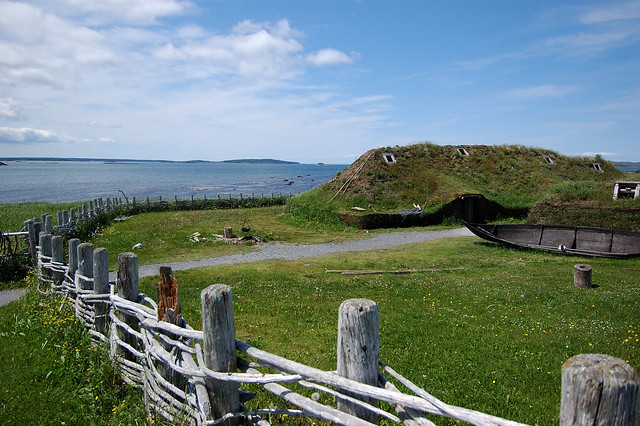
The winter houses were built in villages. They could be different shapes such as rectangles or many-sided. The walls were made from tree trunks and the cracks stuffed with moss. The roof would be cone-shaped like the summer houses and covered with three layers of birch bark with moss and sods between. The smoke hole would be held in place with clay. The entrance was covered with caribou skins. Earth would be banked up against the outside walls and the inside walls were covered with caribou skins.

Birchbark was a very important raw material. Pieces of the bark would be loosened so that the tree wouldn’t die. It was folded into dishes and tightly sewn with roots. Then they would decorate them with stitched patterns using split root strands, and cut the edges in sawtooth patterns.

They made canoes that could carry 8-10 people. They were high and curved in the front and the back, and had sides that rose high in the middle. The sides flared out from a central timber so that they were pointed in the middle. Birch bark would be sewn together to form a single sheet. The smooth inner bark became the outside of the canoe. A piece of spruce lay the length of the canoe in the centre and the bark was folded up. The upper edges were strengthened with spruce poles and it was sewn together with spruce roots. Cross bars were placed at the middle and each end, and wooden slats were laid along the bottom to protect the bar. Curved sticks were placed over them. The canoe was waterproofed with heated tree gum, charcoal and red ochre. Rocks were added to the bottom for ballast and covered with moss.

The men were excellent archers. They carved their harpoon heads, spear and arrow points from bone. They would make blunt arrows for killing birds. During the caribou hunting season, they would fence off areas where they crossed a river or lake and herd the caribou towards this. When the caribou were in the water they would spear them with their harpoons.

Sadly, when Europeans came to Newfoundland, the Beothuk were not able to carry on their lives as they always had. Many died of disease or starvation, or were killed by the white people until there were none left.

PROJECT: Make a cup or dish out of birch bark. wildwoodssurvival.com

BOOK: The Beothuk of Newfoundland: A Vanished People by Ingeborg Marshall, Breakwater Books Ltd., 1991.

Atlantic Puffins

Atlantic Puffin by Andreas Trepte

There’s not too many birds that are cuter than a puffin.

During breeding season, which starts sometime around late April, puffins return to their nesting sites after a winter spent out at sea. Their nesting sites are all on the grassy slopes or near the clifftops of islands. This provides them with a reliable food supply for feeding their young, as small fish are usually abundant in coastal waters. It also provides them with safety as an island or cliff is often inaccessible to mammal predators.

Puffins are monogamous which means they only breed with one another during the breeding season and sometimes stay with the same mate for life. The male makes a burrow in sod or beneath rocks three feet deep ending in a small chamber which they line with grass and feathers. They only lay one egg and then take turns incubating it for several weeks. Once it hatches, they take turns feeding it for another few weeks until it is able to take care of itself. Then they abandon it and head out to sea.

Puffins eat small fish, squid, marine worms and crustaceans. They dive from the surface into schools of fish sometimes going as deep as 200 feet and stay under for up to 30 seconds. Their wings become flippers and their feet are the rudders. They may swallow their catch underwater, or bring it up crosswise in their beaks to take home to the baby chick, called a “puffling”.

The best place to see puffins is Witless Bay where the largest colony in North America comes to nest — around 500,000 birds.

BOOKS: Atlantic puffin : little brother of the North by Kristin Bieber Domm (picture book).

Photo credit: This photo was taken by Andreas Trepte http://www.photo-natur.de.

Icebergs

Newfoundland Lans Aux MeadowsHow much would you pay for a nice, cool drink of iceberg water? In Canada we may not be prepared to pay much. However, considering that 1 in 10 people in the world do not have access to safe drinking water, it becomes a little more valuable.

If you took all the water on earth, 97% of it would be undrinkable. Of the remaining water, up to 2% of that is frozen in glaciers, ice and snow. The remaining 1% is fresh groundwater, soil moisture, lakes, swamps and rivers.

Icebergs are an incredible source of fresh, clean water. The largest iceberg on record in the north was  near Baffin Island in 1882. An average iceberg is around 200,000 tonnes, but this one was over nine billion tonnes! It was 13 kilometres long, six kilometres wide and stood about 20 metres above the water. This iceberg had enough fresh water to supply the world’s population with one litre a day for over four years.

The icebergs you may see off the coast of Newfoundland come mostly from the glaciers of Greenland.  Over thousands of years, snow is packed down, layer upon layer until the accumulated weight turns the lower layers into ice. Under its own weight, a glacier moves outward. The glaciers in Greenland move relatively fast at 7 km per year. As a glacier moves into the ocean, pieces of it break off and become icebergs. Since icebergs are made from snow, icebergs are pure fresh water.

They drift south with the cold Labrador current and can take 2 to 3 years to reach Newfoundland. They melt fairly quickly once they reach the Atlantic and rarely make it much farther south than 40º north latitude, a few hundred kilometres south of St. John’s. They make a fizzing, popping sound as they melt as air trapped for thousands of years is released. Although an iceberg may look big from what is above the water, 7/8ths of it is below the water!

Icebergs can be dangerous if you get too close to them because occasionally they decide to roll over. This can make harvesting icebergs for fresh water particularly dangerous.

The best time to see icebergs off Newfoundland is in the spring and early summer.

BOOKS: Lulie the Iceberg, by Her Imperial Highness Princess Takamado, Kodansha International, 1998 (picture book)

PROJECT: Track icebergs on their way south using icebergfinder. Read about harvesting icebergs.

FILM: Watch the trailer to Chasing Ice.

Atlantic Cod

Would you know a codfish if you saw one?

Atlantic_codBasque whalers called Newfoundland the Island of Cod. When John Cabot came to Newfoundland over 500 years ago, he claimed they were able to catch fish just by putting a weighted basket in the water. For years, cod fishing was the way of life for many who lived in or came to Newfoundland. Those who fished the coastal waters would rise early in the morning, row out to their favourite fishing spot, let down their jiggers and if they were lucky would have a boatload in a few hours. They would row home, split and clean the fish and put them in a salt brine. The salted fish from the day before would be washed and then spread out on flakes to dry. In the late afternoon or if it was going to rain, they would all be gathered up again. It was a family affair.

Those who fished the Grand Banks, would go out in big schooners, 25 men at a time. They would row out from the schooner in dories to set out trawls, then split and salt the fish and put them in the hold. They could be away for weeks.

Later on fishing was mostly done by big boats and big nets which were dragged along the bottom and covered large areas and would catch more than just fish. This helped to mark the end of the cod fishery. In a period of forty years, cod stocks decreased by 97%.

Cod live in waters less than 400 metres deep from Baffin Bay south to Georges Bank. They usually migrate to shallower waters during summer, but some may live their whole life cycle in one bay. They will eat pretty much anything smaller than themselves, even their own young, and feed near the bottom. You can tell how old a codfish is by counting the rings in small “ear stones” in its skull. They take 5-8 years to mature and by then are usually 2-3 kg, and 60-100 cm long. The number of eggs a female lays depends on its size, but a 120 cm female may lay 2 million eggs. However, only 1 in every 2 million survives to reach maturity. The average age of fish caught is 7 years old.

Commercial cod fishing was banned in 1992. Although limited fishing was allowed a few years later, it was banned indefinitely again in 2009 because there was very little, if any, improvement.

Jigging – fishing with an artificial lure or a weighted, unbaited hook attached to a line and jerked sharply upwards. Common to jig for squid and then use it for bait.

Trawl – long row of fish hooks on one main line. Hooks are baited with pieces of herring, mackerel or squid and dragged behind a moving boat.

FIELD TRIP: If your local grocery store has a fish counter, have a look at what is there. Perhaps some of it has come from the Atlantic Ocean. Perhaps you can go to a fish and chip shop for a treat.

PROJECT: Find out about sustainable fishing: Marine Stewardship Council, Fishing CSA

BOOKS: Hold On McGinty, by Nancy Hartry, Doubleday Canada, 1997 (picture book), Saltbox Sweater, by Janet McNaughton, Tuckamore Books, 2001 (childrens fiction).

Place Names

Waterside, St Johns

If you have looked at a map of Newfoundland, you will have noticed that it has some very unusual names: Come By Chance, Happy Adventure, Heart’s Desire, or Seldom… Other names refer to geographical location, such as Flower’s Cove, Cape Broyle, Chapel Arm, Lark Harbour, Leading Tickles, Little Burnt Bay, Lushes Bight, Port aux Choix.

Here are the definitions of some of the geographical terms used:
BIGHT – a curve or recess in a coastline or other geographical feature
TICKLE – a passage between islands
COVE – a small sheltered bay
CAPE – a headland or promontory
PORT – a town or city with a harbour
POINT – a narrow piece of land jutting out into the sea
BAY – a broad curved inlet of the sea
ARM – a narrow body of water or land projecting from a larger body
HARBOUR – a place on the coast where ships may moor in shelter
NOSE – promontory or headland
FJORD – long, deep and narrow sea inlets formed by glaciers

PROJECT: Find an example for each term on a map of Newfoundland and notice how it fulfills it’s meaning.

Newfoundland Dogs

Dogs have always been a friend to mankind. They are the domesticated descendants of wild dogs and wolves. They have been bred to develop certain characteristics producing many different breeds of dogs.

Dogs are built to be able to run down their prey. They have thick footpads which protect their feet when running and claws which protect their toes. Their claws are also useful for digging out their prey. They have a lean, muscular body with a coat of hair.

Dogs show emotion through their actions. If you are acquainted with a dog, you will know how they show with their body their affection, friendliness, anger, fear, shame or excitement.

A dog’s most important sense is that of smell. They use their keen sense of smell to recognize friends and to acquaint themselves with strangers. That’s why dogs come up and sniff at you. Their noses are usually damp which helps them to smell.

Newfoundland DogNewfoundland has a very special breed of dog. It is called a Newfoundland. They are a breed developed from dogs brought by European fishermen hundreds of years ago. It has some Saint Bernard, Great Pyrenees and French hound in it.

Newfoundlands were bred for their environment which is cold ocean, snowy winters and fishing. It is unique in that it has webbed feet – a growth of skin between its toes. It also has large powerful legs, a strong tail that acts as a rudder and lungs that are larger than other dogs its size. This makes it able to swim long distances. It also has an inner coat of fine hair like a mink or muskrat and a thick outer coat of long fur. This keeps it warm and dry in cold water.

Newfoundlands are intelligent, gentle, brave and loyal. They are good with children and will protect their family. They were bred as working dogs to haul sleds or carts of wood, fish and fishing gear, deliver milk and move loads. They are also wonderful water rescue dogs. They were kept on sailing ships to rescue those who fell overboard.

PROJECT: How many dog breeds do you know? What are the different ways dogs are used? If you have a dog as a pet, what breed is he/she and what was he/she originally bred for? Find pictures of different breeds of dogs and paste them on a page identifying the breed and if you can find out, what they were specifically bred for.

BOOKS: Heroes of Isle aux Mortes, by Alice Walsh, Tundra Books 2001 (picture book); Sailor, by Catherine Simpson, Tuckamore Books, 1998 (picture book); Star in the Storm, by Joan Hiatt Harlow, McElderry Books, 2000 (novel); Thunder from the Sea, by Joan Hiatt Harlow, Aladdin Paperbacks, 2005 (novel).

Newfoundland’s Anthem

Newfoundland was claimed by Sir Humphrey Gilbert in 1583 for England and was England’s first land claim in North America. It remained a British colony until 1949 when it’s people decided to join Canada.

The Anthem for Newfoundland and Labrador was written by Sir Cavendish Boyle, governor of Newfoundland from 1901 to 1904. The music was composed by Sir C. Hubert H. Parry and the anthem was adopted in May 1904.

The Ode to Newfoundland

When sun rays crown thy pine-clad hills
And summer spreads her hand,
When silvern voices tune thy rills,
We love thee, smiling land.
We love thee, we love thee,
We love thee, smiling land.

When spreads thy cloak of shimmering white
At winter’s stern command,
Through shortened day and starlight night,
We love thee, frozen land.
We love thee, we love thee,
We love thee, frozen land.

When blinding storm gusts fret thy shore,
And wild waves lash thy strand;
Though spindrift swirl and tempest roar
We love thee, wind-swept land.
We love thee, we love thee,
We love thee, wind-swept land.

As loved our fathers, so we love;
Where once they stood we stand;
Their prayer we raise to Heaven above,
God guard thee, Newfoundland.
God guard thee, God guard thee,
God guard thee, Newfoundland.

BOOKS: Ode to Newfoundland by Geoff Butler, Tundra Books, 2003 (picture book).

Come to Newfoundland and Labrador

12715828_868549599923966_7347677776586943061_o

Sailor’s Warning by Reilly Fitzgerald

Far on the eastern side of Canada, reaching the furthest east of all North America, lies the rocky island of Newfoundland. On the mainland to the west, across the Strait of Belle Isle, lies it’s counterpart, Labrador.

It wasn’t until I came to live on the east coast of Canada that I realized how isolated Newfoundland is from the mainland of Canada. Getting to St. John’s by boat is an 11 hour ferry ride from the northern tip of Nova Scotia. If you want to visit the western side of Newfoundland, it is still a 6 hour ferry ride. Going by air from Halifax is almost as far as going from Halifax to Toronto. And some places along the rocky coastline are still only accessible by boat.

Newfoundland is sometimes called “The Rock” because it is mostly rock. It is part of the old Appalachian mountain chain that also includes Nova Scotia, the Gaspe and eastern United States. In times past, glaciers scraped most of the soil off and pushed it into the ocean. Although this certainly decreased the possibility of agriculture, it helped to build up the Grand Banks off the coast which made for good fishing.

Along the southwest side of Newfoundland is a range of rounded mountains, called the Long Range Mountains. The tallest mountain in this range is Gros Morne at 806 metres. Gros Morne National Park is about halfway up the coast and is known for its amazing fjords (long, narrow, deep sea inlets created by glaciers) and breath-taking views of steep gorges and lakes. Most of the rest of Newfoundland is a highland plateau sloping down to the coastal lowlands. It is a land of forests strewn with ridges and hummocks of rock, thousands of lakes, ponds, streams and bogs.

Labrador, on the mainland of Canada, is part of the Canadian Shield. Only five percent of Newfoundland and Labrador’s population live here. The south is covered in thick forests of black spruce and balsam fir. The north is treeless tundra where the ground is permanently frozen. On the far northern tip lie the Torngat Mountains, with Mount Caubvick reaching a height of 1652 metres. A mighty river runs through Labrador on it’s way to the sea called the Churchill. At one time Churchill Falls was an amazing 75 metre waterfall, higher than Niagara Falls. However, it is now the site of one of the largest hydroelectric dams in the world.

It is mostly cold in Labrador. During the summer it usually has highs of only 15-20 degrees Celsius and during the winter can reach lows of -45. Newfoundland on the other hand is slightly warmer and wetter. The capital city, St. John’s, on Newfoundland’s east coast is known to be the foggiest major city in Canada, as well as the snowiest, wettest, windiest and cloudiest! The fog is caused by the frigid air coming down with the Arctic current and meeting the warm air over the Gulf Stream.

PROJECT: Find Newfoundland, Labrador, the Strait of Belle Isle, Churchill Falls, and St. John’s on a map.

SIGHTSEEING: For some beautiful photos of Newfoundland and other places on the east coast of Canada, you might like to visit this blog: simplelifebyus.blogspot.ca